Barry Magee : One Percent Realty Ltd.

Phone : 604.773.2948 | barry@barrymagee.com

RSS

Discover the Vibrant Charm of Vancouver's West End: Endless Possibilities

The West End, a vibrant and historic neighbourhood in Vancouver, offers a unique blend of urban life and natural beauty. Once the city's first upscale area, its appeal has evolved over time. Originally developed for its clay deposits, the West End became a thriving neighbourhood, with its inclusiveness and diversity being one of its most attractive features today. This community offers a perfect balance for those who crave the energy of city living while still being close to nature.

Location

Vancouver’s West End is a central neighbourhood located in downtown, taking on a trapezoidal shape. Its borders stretch along Burrard Street, head west on W Georgia toward Stanley Park and the Lost Lagoon, then south along Park Lane (or Denman Street, depending on the perspective). The neighbourhood wraps back along Beach Avenue, parallel to the Seawall (English Bay), finishing near the Burrard Street Bridge.

Housing Market History

The West End is home to a variety of living options, including mid-rise and high-rise buildings, appealing to both renters and buyers. Additionally, many older, renovated single-family homes are available. The streets are lined with trees, and green spaces provide peaceful buffers from the hustle and bustle of the urban environment. As Vancouver has expanded, the West End has seen a rise in condo developments, which reflects the city’s overall growth and planning. The neighbourhood remains popular across age groups and appeals to both newcomers and long-time residents, thanks to its proximity to the downtown core and Stanley Park. Housing prices in the area continue to rise, but they remain accessible, offering those who live there a full Vancouver experience.

Recreation and Outdoor Activities

Residents of the West End enjoy a variety of recreational options. The West End Community Centre, a 50,000 square foot facility, offers a library and indoor activities. The Vancouver Aquatic Centre, located on Beach Avenue, is another popular spot for fitness and leisure. Two notable outdoor parks are Nelson Park, centrally located in the neighbourhood, and Sunset Beach Park, located where False Creek meets English Bay. Sunset Beach Park is also home to Vancouver's annual Celebration of Light fireworks festival.

Directly west of the West End is Stanley Park, one of Vancouver’s most beloved attractions. This expansive park offers year-round access to nature, with miles of trails perfect for hiking, jogging, and cycling. Other recreational facilities within the park include tennis courts, lawn bowling greens, rugby fields, and a pitch-and-putt course.

Dining and Shopping

The West End boasts an eclectic mix of dining and shopping options, with Davie Street, Denman Street, and Robson Street forming the heart of the neighbourhood's commercial area. Robson Street, known for its high-end boutiques and world-class amenities, offers a variety of restaurants, cafés, shops, salons, supermarkets, theatres, and hotels. It’s one of the most vibrant and lively neighbourhoods in Vancouver, where urban culture meets cosmopolitan flair.

Schools in the Area

The West End is served by several schools, including Lord Roberts Elementary, Lord Roberts Annex, and the prominent King George Secondary. For those seeking private education, Pattison High and Westside Preparatory are nearby options.

Higher education is also accessible, with the University of British Columbia (UBC) offering law and medicine courses at its downtown campus at Robson Square. UBC’s Sauder School of Business also operates in this area, along with branches of the UBC library and bookstore. Additionally, Simon Fraser University (SFU) has a downtown campus, with programs in contemporary art and business, including the Segal Graduate School of Business. BCIT, located on Seymour Street, is another local institution offering a wide range of courses.

Transportation Options

The West End is well-connected to the rest of the Lower Mainland, making commuting convenient for its residents. The Stanley Park Causeway leads to the Lions Gate Bridge, providing access to West Vancouver, North Vancouver, and Whistler. W Georgia Street heads east toward Highway 99 and the Trans-Canada Highway. Public transportation is easily accessible, with buses, SkyTrain, and the Canada Line connecting the West End to destinations like UBC, Vancouver International Airport, and the surrounding areas. The Seawall and the neighbourhood’s commercial district also encourage walking and cycling.

The West End continues to attract people of all ages and backgrounds, from singles to families. Robson Street offers endless shopping and dining opportunities, while schools like Lord Roberts and King George High School serve the area’s families. With its vibrant urban lifestyle and proximity to nature, the West End remains one of Vancouver's most desirable neighbourhoods.

Browse West End listings for sale : https://barrymagee.com/recip.html#!/wps/-/noframe~true/recip/59576/idx.search?idx_v2_map_pos=49.2901|-123.1376&idx_v2_map_zoom=07&idx_v2_map_radius=2.5

Read

Peat Bogs: Vancouver’s Hidden Underbelly

Uneven roads, crooked fences, and tilting houses – these signs often point to one of Vancouver’s peat bog areas. Many people are unaware that large parts of the city were once swampland. To make way for development, these areas were drained to appear like solid ground. However, early Vancouver settlers didn’t realize that the land beneath was still unstable. This situation can create challenges for potential homeowners, as properties in these areas might be poorly constructed on peat, or if you're building a new home, you may face extra construction hurdles.

Where Are Vancouver's Peat Bogs?

Historically, Vancouver had many rivers and streams meandering through the city. A glance at old maps shows the numerous waterways that once flowed through the Lower Mainland—believe it or not, Broadway used to have multiple streams running through it!

This abundance of water contributed to the formation of extensive marshlands and swamps, giving rise to the region’s peat bogs. To make room for the city’s expansion, many of these wetlands were drained, but the peat remained underneath. The map below outlines the approximate locations of these peat bogs in Vancouver, marked in dark green

What Is a Peat Bog?

Peat bogs are wetlands made up of organic material that decomposes slowly over thousands of years. Many professionals compare peat to a sponge: when it dries, it contracts, and when it's saturated with water, it expands. This causes structures built on peat to shift, often resulting in uneven buildings and infrastructure.

How Does Peat Affect Home Value?

Living on peat bog land typically reduces a property’s value. This is because the land is considered unstable and more difficult to build on compared to non-peat areas. Older homes, particularly those built before the 1960s, may have been constructed on unstable land, which can be problematic for homebuyers.

Peat Bogs Can Be a Hidden Opportunity

Despite the challenges, some of Vancouver’s most desirable neighborhoods lie on or near peat bogs. Areas like Kerrisdale, Arbutus, Trout Lake, Mount Pleasant, and Hastings-Sunrise, which are popular with buyers, are all located on peat bogs. If you’re willing to look past the risks, buying a home in these areas might offer a unique opportunity to invest in a vibrant neighbourhood at a discount.

But Keep in Mind – This Discount Can Come With Risks

Found a dream home that seems too good to be true? Check the map – it may be on one of Vancouver’s peat bogs. The reason properties on peat land are priced lower is due to the additional risk and costs associated with the land’s instability.

What to Consider When Purchasing a Peat Bog Property

1. Building on Peat

Building a structurally sound home on peat is possible, but it requires special techniques. Two main methods are typically used to secure buildings on unstable land:

  • Digging Out the Peat: This involves removing the peat until solid soil is found beneath. However, this process can be risky, as draining water from one property could destabilize neighbouring homes, causing them to sink.

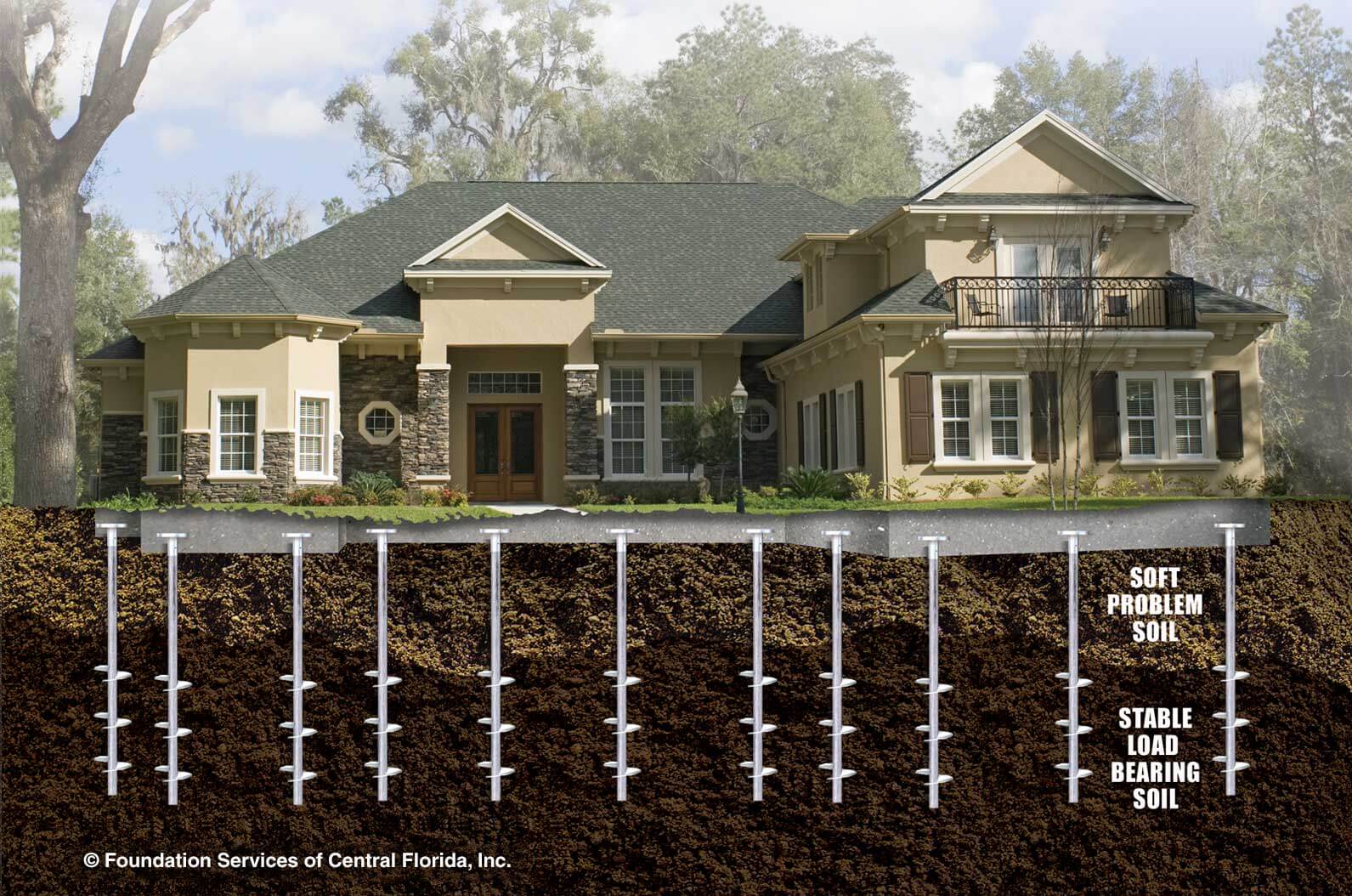
  • Helical Piles: This technique involves drilling large screw-like piles into the ground until solid soil is reached. A grid of these piles supports the house’s weight, offering a safer, more stable foundation. Since this method is less disruptive to neighbouring properties, it’s considered the more reliable option.

Building on peat often requires specialists to ensure the home is safe and up to code, leading to higher construction costs. Given that the work can be specific to each site, due diligence is crucial before committing to the purchase.

2. Inconsistent Peat Depths

Peat bogs vary in depth. For example, while the front of a house may rest on solid ground, the back might be built on several feet of peat. The deeper the peat, the more expensive and complex the construction process, especially when using helical piles (often charged by the foot).

Since peat consists of decomposing organic matter, it is always shifting. This ongoing movement can cause unpredictable changes in the land over time.

3. Mitigating Risk

Before buying a property on peat land, do thorough research. Work with a trusted realtor who can help you navigate the process, and consider consulting with construction and engineering experts. Knowledgeable professionals can help you assess the risks and understand the full scope of what you're getting into.

How Can You Tell If a Property Is Built on Peat?

Your realtor can advise you if the property you’re interested in is on peat bog land. I always work to ensure that you have all the information necessary to make informed decisions.

Did You Know Shaughnessy is Surrounded by Bogland?

The peat bog map reveals interesting insights into the history of Vancouver’s development. Shaughnessy, an upscale residential area, was developed by the Canadian Pacific Railway (CPR) in the early 1900s. Although Shaughnessy was intended as an alternative to Vancouver's West End, it is nestled between two large bogs, which could be a reflection of how the city’s developers viewed the land. While we can only speculate about the reasoning, it certainly adds an intriguing layer to the area's history.

Neighbourhood Spotlight: The Camosun Bog

One of the last remaining examples of Vancouver’s original peat bogs is the Camosun Bog, located in Pacific Spirit Park. The Camosun Bog was historically used by the Musqueam people for food, medicine, and trade. Though much of the bog was lost due to human activity, restoration efforts began in 1995. A boardwalk was built to allow the public to walk through the area and learn about Vancouver’s natural heritage. It’s a peaceful spot to visit and gain an appreciation for the land on which the city was built.

Read